 It has been over ten years in the making, but at long last my Cornish language map of Cornwall is back from the printer. This map has been produced jointly by myself and the place name panel of the Cornish language umbrella body Akademi Kernewek and its predecessor, the place name and signage panel of Maga (Cornish for Growth), the Cornish Language Partnership /Keskowethyans an Taves Kernewek, an organisation which was wound up in 2015 and whose functions were taken over by Cornwall County Council’s Cornish language development office and Akademi Kernewek.
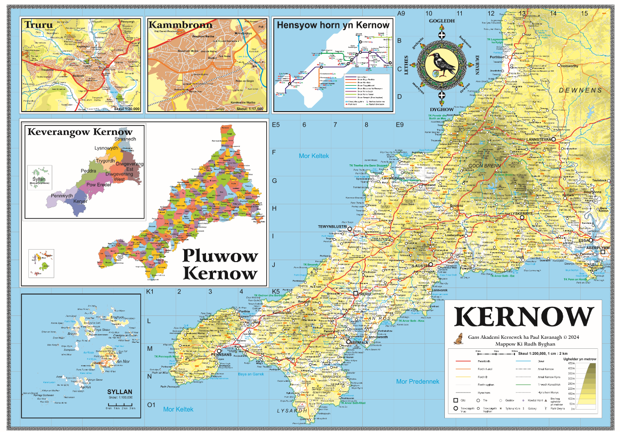
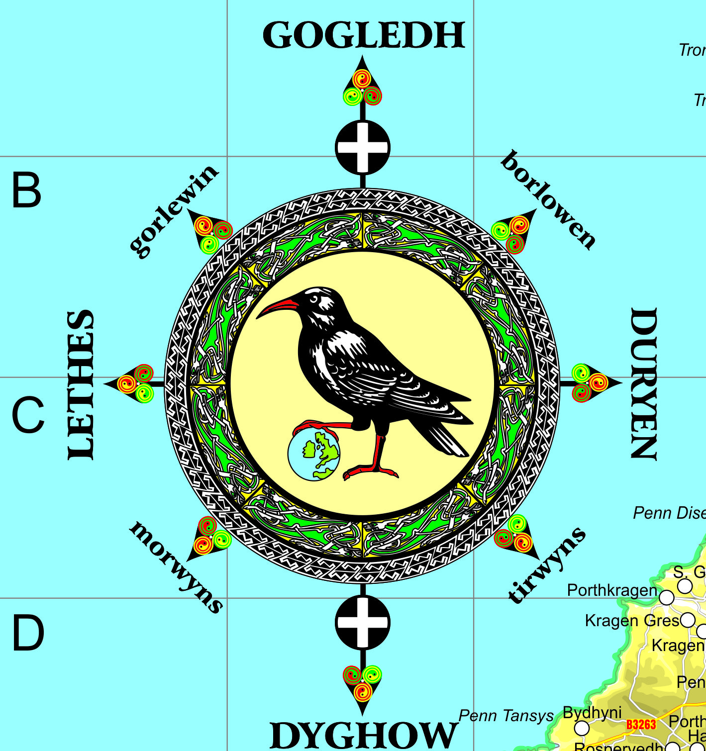
 This map contains approximately 1200 place names in the Standard Written Form of Cornish, all of which have been researched and agreed by the place name panel of Akademi Kernewek. This map is the first ever detailed Cornish language map of Cornwall, a map of Cornwall as a country with its own distinct language and culture, meaning that for the first time ever, Cornish people – and the rest of us – can see Cornwall through the prism of Cornwall’s own language. The map is entirely in Cornish, the place names, the legend, and all the text. I drew and designed the map and all the graphics and artwork. The Celtic knotwork border which frames the map is in black and white, a nod to the white cross on a black background of the Cornish flag. The Cornish Celtic compass contains a chough, the national bird of Cornwall, grasping a globe, signifying that the Cornish language is a language for the modern world.
 Because all the names and Cornish language text have been agreed by Akademi Kernewek and are in the Standard Written Form of Cornish, this map is as official as it is possible for a Cornish language map to be. I hope that the map will be of interest to anyone who wants to learn Cornish, to promote or celebrate Cornish, or just as a statement of pride in Cornwall and its venerable Celtic language.
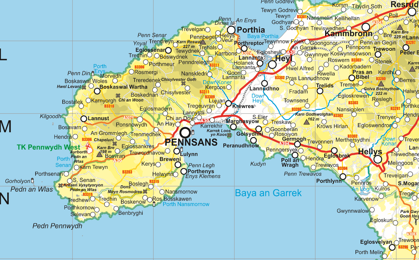
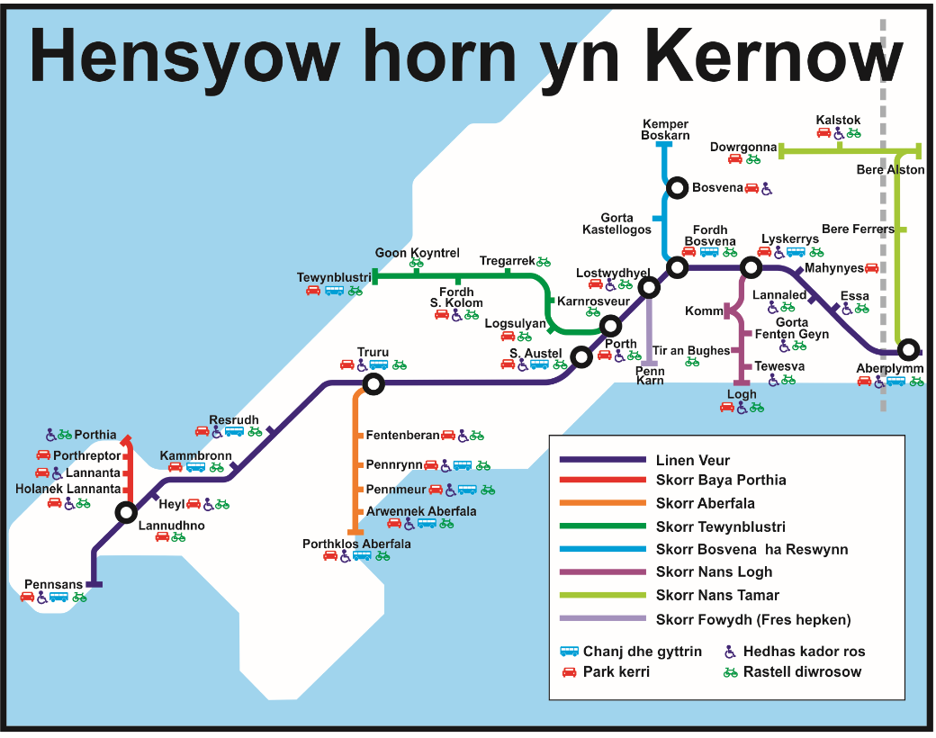
The map consists of the main map of Cornwall at a scale of 1:200,000 or 1 cm 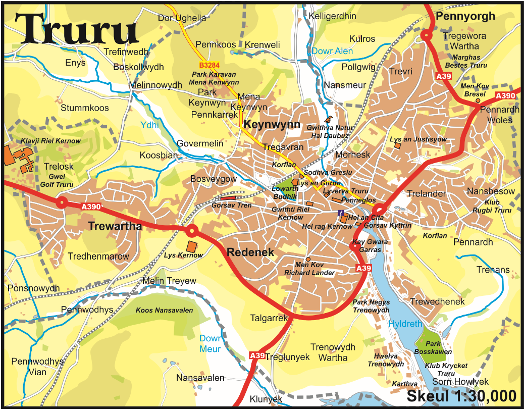 to 2 km. It is printed on heavy 250g paper and is A1 in size – 59.4 x 84.1 cm and will make an attractive wall map. The map also contains insert maps showing extra information in greater detail, again all in the Standard Written Form of Cornish. There is a map of the Scilly Isles at a scale of 1:100,000 or 1 cm to 1 km, a map of Cornwall’s civil parishes, a map of the Cornish hundreds or traditional districts, and finally there are detailed maps of the Cornish capital of Truro, the largest town, Camborne, and a schematic map of railway lines in Cornwall in the style of the famous London Underground map, which I hope may help prompt train operators in Cornwall to agree to bilingual station name signs such as already exist in Scotland and Wales.
Back in spring 2014 I was a full time carer for my late husband Andy, who at the time was in the advanced stages of vascular dementia. I had already produced a Gaelic map of Scotland and was in search of another project which could give me something to take my mind off the stresses of caring full time for a loved one with advanced dementia who could not be left unattended. Celtic language maps were something I could do on the computer in the corner of the living room where Andy could see me – if he lost sight of me he panicked because he could not remember where I was.
 I figured that a Cornish language map of Cornwall could be a manageable project which could be completed in a couple of months. Famous last words. I had found the list of place names in the Standard Written Form of Cornish which had been put online by Maga and realised they provided an ideal launch pad for a detailed Cornish language map. The map itself was drawn fairly quickly using copyright-free and open source resources, then the work of putting in Cornish language names could begin.
However it soon transpired that some 300 names had yet to be researched and the map stalled at that point. Then life intervened. Andy passed away in September 2014, I moved house, started writing for The National, met my current husband, and after some years of a long distance relationship back and forth across the Atlantic, we got married, he moved to Scotland, I suffered a massive stroke which left me disabled, and we moved house again.
But it always annoyed me that I had not completed the Cornish map. It was unfinished business. In Autumn 2023 I happened to look up one particular place name that had always bugged me, Dozmary Pool, and discovered that the Cornish Language Partnership had been superceded by the Akademi Kernewek and that its place name panel had researched many of the names that had been missing from the map. I got in touch with the Akademi and was delighted to find that they were as keen as I was to get this project completed. Over the past few months we have worked together to finalise all the names and Cornish language text on the map.
The map is, at long last ready. It will be officially launched at an event at Kresen Kernow, the Cornish Archive Centre, in Redruth on 26 June between 1pm and 4pm. I will be travelling to Cornwall for the launch. The map will go on sale throughout Cornwall after that and will be distributed and sold by Cornish language organisations. However I have a limited number of pre-publication copies for sale through this blog.
The maps cost £15 each plus £7 P&P within the UK. A total of £22. Payment can be made by PayPal to weegingerbook@yahoo.com. Please remember to include the postal address you want the map sent to. Postage to locations outside the UK can be expensive please email me at weegingerbook@yahoo.com for details.

Wondering if you could be interested in doing one for Devon. its only about 400 years since the language died out in Devon.
Congratulations! That’s quite an achievement and a beautiful map. I recently watched a video in the RobWards channel talking about the Celtic languages in Britain and Cornish is one of them.
http://www.youtube.com/watch?v=mroBpgBw0gU
Hope you have a great time in Cornwall.
Brilliant, know a few Kernow ‘natives’ who I am sure will be very interested!
Verry impressive.
[…] Source […]
Paul what a marvellous achievement . Enjoy your visit to Cornwall… fabulous part of the world.
hugs
Molly
Congratulations.
Great map1
Fantastic, a Labour of Love. Well done sir.
Hello, Is the map of Scotland also A1? Thanks.
No, the map of Scotland is A0 but the copies I have of it for sale were printed a long time ago. Print costs have doubled in the intervening period.
Prof Robertson has an interesting table demonstrating that France based IPSOS have consistently shown YES to be in the lead in their Scottish polls. It seems the closer you are to London and the Tories the more consistently you find NO in the lead. Strange.
Find Out Now are also YES friendly.
https://talkingupscotlandtwo.com/2024/06/12/once-more-global-pollsters-with-no-ties-to-london-find-yes-ahead-again/
42% of voters might still change their mind on voting intention.
and 25% intend to vote tactically to keep another party our. Labour are the most likely to do that. All the attributes of a dog except loyalty!